1846 OLD BROOKLYN FARM LANDS
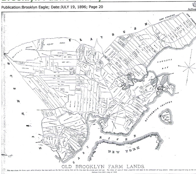
1846 OLD BROOKLYN FARM LANDS
Source: 19 July 1896 Brooklyn Eagle explains the lands and those who owned them. Good Crops Were Grown by Their Thrifty Proprietors Where Residences and Factories Now Exist. It was only twelve years before the opening of the present century, or on March 7, 1788, that the town of Brooklyn was recognized by the state government. Just 143 years before, or in 1645, the first Dutch settlers gave to the district on eighter side of that part of the highway to Flatbush, which has since been known as Fulton street, the name of Breuckelen, after a town in Holland. There was then nothing to suggest the modern city of to-day, only a sparse and scattered population laboring industriously to repair the ravages of the revolution, subsisting on homely fare and being strangers to luxury. Increasing facilities of communication with New York paved the way for growth of a village on the side of the river where formally all had been farmers or fisherman, and Brooklyn village, which was twenty-eight years younger than the township, was incorporated on April 12, 1816, having been previously created a fire district by the legislature of 1801. It is highly interesting to recall the condition of things which then existed, the status of landed property held by a few proprietors whose names we find in our deeds and whose family appellatives are preserved in the streets of the great city which has sprung up on and extended far beyond the area occupied by their farms. The old village. which was laid out in streets in 1819, included part of the First and Second Wards and the Fourth and Fifth wards. When the century opened the two most important land owners in the vicinity of the ferry were Comfort and Joshua SANDS, whose farms included all of the Fifth and about half of the Fourth wards and were bounded by the river, Fulton street, the Navy Yard and Concord street. The Sands property was broken up about 1802, when the owners began subdividing it into building lots. They argued that the hill so fashionable and exclusive, was too steep and difficu1t of access to be available for residence purposes. The two SANDS farms had, before the revo1ution belonged to Jobn RAPALJE, a greatgreat-grandson of the first settler, and a wealthy tory land owner, whose adhesion to the mother country led to the confiscation and sale of his property by the state authorities. Comfort and Joshua SANDS being the purchasers. The price paid for the property at the sale on July 13, 1784 was £12,430 in state scrip. The area of the farm was 160 acres. It was first surveyed for subdivision into building lots in 1787 and received the name Olympia. In 1800, according to a scrapbook compiled by General Jeremiah JOHNSON, Kings county had 4,495 inhabitants, of whom 621 were electors; 930 free white-males, of 10 and upward; 700 free white males under that age; 1,449 free white females; 1,432 slaves and 46 free persons not enumerated. The inhabitants were chieftly of Dutch extraction. The slaves were treated well, but the opinion re1ative to their freedom was wholly influenced by pecuniary motives. It was claimed for the SANDS tract that it was better situated than any other near New York for the counterpart of that city. It was certain that, the southern side of Brooklyn ferry (the heights), the hills were so high and such astonishing exertion was necessary to remove them, that the Brooklyn Ferry section could never extend and great distance upon that quarter and all improvements must necessarily be made in Olympia. More ever Olympia and Brooklyn ferry must always continue to increase in a ration with New York. But as that city could never extend further southward, but was continually progressing in the contrary direction it was evident that Olympia must receive the whole progress which otherwise would be given to Brooklyn ferry. Olympia. was extremely well callculated for a city, situated on a point of land which presented its front to the East river, surrounded almost with water; The conveniences were most manifest. A considerable country in the rear afforded the easy attainment of produce. A pure and salubrious atmospbere, excellent spring water and good society were among a host of other desirable advantages. As regards health in particular it was situated on the natural soil-no noxious vapors, generated by exhalations from dock logs, water and filth sunk a century under it's foundation, were raised there. Sand and clay for building were in the village. Stone was brought from a short distance. Timber, lath and boards were to be had on the spot. In fact almost every article for building was afforded here as cheaply as in New York. Could the inhabitants once divest themselves of their dependence upon that city, and resolve that their own village should prosper, they would require no supernatural agent to foretell the consequence. The principal steets in this Village were 50 feet wide, but the cross streets were not so broad. They were not yet paved, though a vast number of pebbles were there for the purpose. Latterly, it seemed to have had the appearance of a regular town. Edifices were being erected and other improvements constantly being made. In view of the elevated situations, the agreeable prospects, the salubrity of the atmosphere and the contiguousness to New York, with many other interesting advantages, it claimed more consideration than any other part or the township. As a retreat from New York in summer, Olympia, furnished many superior excellancies over other places; such as its vicinity to that city, the opportunity of freighting and unloading vessels during the period of fever and the sale of goods to the yeomanry who were fearful of entering the city. This village had no peculiar priviledges of its own. Joined with the several townships it supported two ministers. There were eight grist mills, which ground by means of the tide of the East river. Some of these mills were employed to grind grain for exportation; others to supply the neighboring farmers. Cables, cordage, lines and twine were spun and laid to considerable profit. A new patent floor cloth manufactory was about to be introduced. Brewing and distilling with a capital, might be carried on to advantage. There were three schools, one at Bedford, one at Gowanus and the other at the Brooklyn ferry. This last claimed the preference, having been established a considerable length of time. There were about sixty scholars who were taught the common rudiments of education..with English grammar, geography and astronomy. After speaking favorably of Thomas KIRK'S newspaper the Courier, then in its first year, General JOHNSON states that there were no libraries nor places for the sale of books in the town. There was but one society. properly speaking, in the township and that was the Masonic erected in 1798, in Olympia, with a meeting place at the corner of Main and James streets. Two volunteer companies, handsomely uniformed were then in existence and a powder house and arsenal a1ready established. The writer then proceeds to urge the necessity of incorporation as a village, as the time had arrived for making appropriations for extensive market places, a square for an academy, another for a promenade, others for public buildings of different sorts, as churches, court houses, almshouses, etc. The Navy yard dates from this period and the land it occupies was purchased by The United States government for $40,000. Simultaneously with this improvement a portion of the Comfort SANDS property was purchased by Irish refugees who came to this country after the suppression of the rebellion of 1798. The only other farms in the old Fourth and Fifth wards were those of Jobn KOWENHOVEN and the Rev. John B. JOHNSON, who preached in the old church standing where the Brooklyn theater burned down in 1876 during a performance of Kato CLAXTON, and where the Eagle building now stands. The JOHNSON farm which was about one-third of the SANDS property in size, and the KOWENHOVEN estate, were sub-divided into lots in 1825. At his death Mr.JOHNSON left two sons and a daughter and a considerable part of the old estate is still held by members of his family. The First ward was occupied by the HICKS and MIDDAGH farms, the land being about equally divided between the two families. The boundaries were Fulton street, East river and Clark street. The dividing line was midway between Hicks and Henry streets. HICKS having all the west and MIDDAGH having all the east section. South or the Middagh farm were the small WARING, KIMBERLEY and Samuel KOWENHOVEN properties. Another o1d time land owner was the famous Dr. SWEETCOPE, a Hessian who had served in the British army during the revolution and remained here after the close of the War. He had an office at the corner of Fulton and Clinton streets and his property lay along Love lane, which then ran from Fulton street to the river. Just south of Love lane approximately between it and Remsen street and from Fulton street to the river, lay the track purchased by Hezekiab D. PIERREPONT in 1804, the northerly half of De BEVOISE and the southerly part from the REMSEN'S. These titles date back to the Indians and the Dutch period. The PIERREPONT mansion was WASHINGTON'S headquarters during the campaign made memorable by the battle of Long Island and from it the orders for the retreat were issued. Mr. PIERREPONT amassed a fortune from gin, his distillery being located at the foot of Joralemon street. The building was the old LIVINGSTON brewery, which was in operation during the revolution and produced beer which was greatly appreciated by the British soldiers in the hospita1s, twenty barrels a day being the usual amount consumed. This building was afterward used as a candle factory and later as a sugar house. It burned down finally after which apartment houses to accommodate five hundred families were erected on the site. Between Remsen and Joralemon streets was the REMSEN farm, which extended back from the river to Fulton street and remained in that family till the thirties. The area between Joralemon and State streets constituted the old Philip LIVINGSTON estate, which extended from the river up to Boerum place or Red Hook lane. The lane then extended to Red Hook Point but was afterward closed except between Fulton and Livingston streets. The LIVINGSTON mansion was the the family summer residence and in 1803 the land included in the estate was purchased by Tunis JORALEMON, a Jerseyman of Dutch extraction who sold milk and vegetables in the New York market and utilized his purchase for dairies and garden purposes. Mr. JORALEMON was born in 1760, and was for awhile a harness and saddle maker near Flatbush. He was a prominent man in the Dutch church and was justice of the peace and a.trustee of the village from 1817 to 1821. In person he was tall, slim and slightly bent: his austere features strongly resembling the portraits of Dante the great Italian poet, and his manner was energetic and determined. He was most obstinate1y oppossd to having streets opened through his farm. In 1826 Charles HOYT forced Henry street through it. This marked the commencement of land speculation in Brooklyn. A little afterward Mr. PIERREPONT, who had laid out a street through his own estate called Clinton street (because it was projected at the time when that celebrated statesman succeded in carrying out his great Erie canal project), endeavored to force it through JORALEMON'S land by action of the village trustees. Mr. JORALEMON opposed it bitterly, mainly because disliked CLINTON and his big ditch, and did not wish a street named after him. He died in 1840 leaving behind him an honest man and a property which, at the time, was estimated as worth from $600.000 to $700.000. In 1841 the old LIVINGSTON mansion, which he had so long occupied was destroyed by fire. Two mayors of Brooklyn, Samuel SMITH and T. G. TALMADGE, married daughters of Mr. JORALEMON. Between State and Amity streets and Court street and the river lay the farm of Ralph PATCHEN comprising 150 acres, purchased from William CORNELL, one of the three sons of Whitehead CORNELL. The elder brother, John CORNELL, received from from his father, 60 acres, including the old Seabring, or "Red Mills," where he pursued the milling business; the flour of his make enjoying a high reputation even in the English market. The tract between Amity and Congress streets, and Court street and the river, which had originally belonged to the REMSEN and LIVINGSTON estates. was purchased by Cornelius HEENEY, who was born in Queens county, Ireland, in 1757, and came to this country in 1784, The vessel in which be sailed was struck by lightning and wrecked in Delaware bay and he with others of the passengers and crew were rescued in oyster boats, which had been plying their vocation in the bay. The captain of the boat of which HEENEY and some others came ashore demanded a dollar from each, which all cheerfully paid except HEENEY, who had not a dollar to give. In his dilemma he applied to a friend for the loan of the needed sum, which was immediately handed to him, and when he inquired the name of his benefactor, with a view to ultimate payment, the kind Quaker simply replied: "Whenever thou seest a fellow creature in want of a dollar, as thou art now, give it to him and thou wilt have repaid me" -- A circumstance which made a lasting impression upon Mr. HEENEY'S mind. His first employment was with a Mr. MEAD, a Philadelphia lumber merchant and a Quaker. His services were so efficient that he was recommended to seek his fortune in New York. Arriving there, he was employed by a Mr. BACKHOUSE, who was also a Quaker and the only merchant who sold exchange on England. Here be became acquainted with John Jacob ASTOR, then a porter, and when Mr. BACKHOUSE subsequently retired from business he sold out to HEENEY and ASTOR, who became partners. ASTOR'S ignoranoe of bookkeeping led him to suspect his partner, who was an expert accountant and this difference resulted in the dissolution of the firm, HEENEY carrying on the firm business alone for many years with great success. He purchased a three story building, with a store underneath, at 82 Water street, New York, and occupied it till it was burned down in the great fire of 1835. In order to secure a debt of $30.000, he took the large property in South Brooklyn, near the South ferry, then supposed not to be an adequate equivalent for the debt, but, which at the time of his death, was valued at over $200,000. After the purchase of this property he made it his summer residence, and when his Water street house was burned down he removed permanently to Brooklyn, where he spent the remainder of his days. HEENEY, who was never married, was pleasant and affable, fond of a joke and repartee, warm hearted and social and generous to a degree. Many orphan children were educated by him, and not a few of his female proteges married into highly respectable families, whose descendants now occupy enviable social positions in both cities. Hs fine Brooklyn orchard was utilized every summer for fresh air parties for orphan children, who were given all the apples, cherries and other fruit they could consume. Wood was also distributed gratuitously to the poor of the neighborhood, all receiving as much as they could carry away. He gave $18,000 to the Brooklyn Roman Catholic Orphan asylum, and contributed largely to several of the charitable associations and churches of New York and Brooklyn. Despite the fabulous rapidity with which Mr. HEENEY'S property rose in value, these gifts left him comparatively poor. When be died, May 3, 1848, at the age of 94, his estate was worth little more than $15,000. The institution receiving his Brooklyn real estate adopted the policy of giving only lease-hold titles and reserving a ground rent as yielding the largest income on the property. Parmenus JOHNSON was the owner of the land bounded by Congress and Baltic streets and Court street and the river, and this farm was cut up and sold off in small plots in 1833. Mr. JOHNSON came from Oyster Bay, Long Island, about 1818, and purchased sixteen acres of the old Rymer SUYDAM farm, to which he added forty or more acres by filling in and docking out upon his water front. He married a daughter of old Judge JORALEMON and became by the rapid rise of real estate one of Brooklyn's wealthiest citizens of the time. The old Rymer SUYDAM house stood on the site of the JOHNSON residence, at the corner of Hicks and West Baltic streets, which was surrounded by pear trees a century old. At that time the water came up as high as the present line of Henry street. The CORNELL farm, which was about the same size as the SANDS property extended from Baltic street, beginning at Court, to Red Hook lane, the old time road, which took a diagonal course to Red Hook. Like the other large holdings, it was subdivided and sold in small plots. The late Henry L. CLARKE, who died at the age of 80 years, married a CORNELL. When a young man, he sold man he sold considerable property, for which confirmatory deeds had afterward to be given, in consequence of his wife being a minor. No streets had then been laid out on the property thus disposed of, so that serious trouble arose from these transactions on the paper map. Some of this property was purchased by Char1es HOYT, a prominent real estate speculator in the thirties. A similar difficulty as to uncertainty of street lines arose in the tract comprised in the Rose Hill farm, in the Ninth ward, bounded by Park street and St. Johns place, Flatbush and Fifth avenues. On the south side of Hamilton avenue, the Red Hook Point section was nearly all owned by the VAN DYKES and LUQUEERS. The point was the same as the vicinity of Jamaica bay is now, and was cut into by inlets and dotted with grist mills, operated by the tide water. The well known Stranahan improvement of the Atlantic basin was a part of this property. Nearly all of the Twelfth ward, except the Jacob BERGEN estate, belonged to the VAN DYKES and LUQUEER families. The older LUQUEER, Abraham, died in 1823, and his son, Nicholas, in 1864. The BERGEN estate, by the way, took up a good portion of the Twelfth ward and half of the Tenth ward, between Gowanus Bay and Clinton street and Butler and Hoyt streets. Mr. BERGEN, who died in 1847. sold one large piece to Jordan COLES. the balance of his estate being spilt up among heirs. A number of old farms were bought up in the thirties by a pushing speculator and builder, Anson BLAKE, who was at one time mayor of Brooklyn. and died in 1868. The Third ward was made up of the farms of Samuel SMITH SCHERMERHORN VAN BRUNT estates, beside the smaller VON GERICHSTON DEBEVOISE holdings and the Mary POWERS piece. A considerable part of the SCHERMERHORN property still remains in the family. Mrs. POWERS' son, George A. POWERS, is now a prominent resident of this city. In the Eleventh ward the prominent families were those of Dr. John DUFFIELD, Samuel FLEET, Samuel JAMES, Samuel KOWENHOVEN, J. K. St. FELIX and John C. COWENHOVEN, the last of whom was or the family which in the seventeenth century were the largest land owners in the county. The old county poorhouse, which was acquired in 1825, was bounded by Flushing and Portland avenues and Navy and Willoughby streets. It was used as a public burying ground till the city began selling it off in 1845, at the time the new poor house was located in Flatbush. The Twentieth ward farms were those of KOWENHOVEN, John and Samuel KOWENHOVEN, John and Jacob RYERSON John and Jeremiah V. SPADER and the William Gerardus POST farm. These properties were split up about 1845. In the Seventh ward the landowners were more numerous. The list including John, Jacob, and Martin RYERSON. John KOWENHOVEN, Tunis SCHENCK, Jeremiah JOHNSON, John SKILLMAN, Tunis JOHNSON, Philip REID, Tunis KOWENHOVEN Rem LEFFERTS and Leffert LEFFERTS, The MESSEROLE farm. When Judge Leffert LEFFERTS died in 1847 he was one or the largest real estate owners in the city. One child married Henry L. BREVOORT, recently deceased. Samuel J. KOWENHOVEN, at his death gave his property to his nephew John, for life, after which it was to go to his heirs. John JACKSON died in 1861. The face of the property forcibly illustrates the results that so often follow the transformation of agricultural lands into city property. Such portion of the estate as fell to the daughters were judiciously managed and still remains in their families. The sons, however were less fortunate, and most of their inheritances were lost. Coming to the Twenty-First ward bounded by Flushing & Bedford avenues & Lafayette avenue & Broadway, we have the farms of: Garrett NOSTRAND, Henry BOERUM, Jeremiah RAPELYE, Jacobus LOTT, Frances VANDERVOORT, Jeremiah MESEROLE, Samuel MEEKER, Charles DELMONICO and Amasa WRIGHT. These holdings were successively split up in the 30s and 40s. The Twenty-Third ward land owners were: Tunis JOHNSON William SPENCER Rem & Leffert LEFFERTS James DeBEVOISE Maria LOTT Charles C. BETTS, who died in 1882, and whose estate was disposed of in a partition suit a year later. Small portions of the farms of: Dr. N. A. GARRETTSON Philip REID William PHILLIPS Jeremiah RAPELYE and Jacobus LOTT were also in this ward. The remainder of the several properties being in the Twenty-fifth ward. Other owners of lands in this ward were: Jeremiah MESEROLE Hendricks SUYDAM James LEFFERTS John RYERSON Messer. RADDE Messer. SACKMAN Messer. RADENACHER. They are all represented by descendants, while their property was subdivided for speculative purposes from fifty to sixty years ago. The Twenty-fouth ward list of land owners consisted only of: Leffert LEFFERTS Samuel GARRISON Jeremiah REMSEN The balance of this section of the city being taken up by the wood lots. These were forest lands, which were originally the common property of the town, and were divided among the various landowners early in the last century. Within the limits of the Ninth ward, bounded by: Franklin and Atlantic avenues, Flatbush avenue and the town of Flatbush which preceded the urban development, were the properties of: Nebemiah DENTON Robert DeBEVOISE Abraham LEVERY Robert WILSON Nicholas COMOVEN Andrew PARMENTIER James PEARSALL John LEFFERT James UNDERHILL Nathaniel DENTON Rem * Leffert LEFFERTS Moses SMITH Levi HART Anthony KERR BROWER farm BAILEY farm VAN CLEEF farm. A considerable part of the Ninth ward was taken for Prospect Park and as it was not used intended, the city endeavored to sell it in 1878 and again in 1881. There were no buyers however, at either sale through an apprehension of the validity of the title. It was not till the whole matter had been passed upon by the court of appeals that these doubts vanquished and the city was able to sell the propery in question. The farms comprising the area of the Twenty-second ward were owned by: Thomas POOLE P.V. REMSEN Rose HILL Farm Charles HOYT Theodore POLHEMUS Adriance and Jake CORTELYOU Thomas TALMADGE Rem ADRIANCE Adriance VAN BRUNT Henry L. CLARKE Richard BERRY John and Peter WYCKOFF. In the Eighth ward we find the list of landowners: Henry and Peter WYCKOFF Henry STORY B. WINAND Joseph DEAN Cornelius BENNETT Schermerhorn GARRETT John S. BERGEN Henry POOLE John L. DELAPLAINE John S. BERGEN Theodore VAN PELT Cornelius BERGEN Henry A. KENT Thomas HUNT who died in 1878 was before the war one of the largest real estate holders in the city. There was a general sale of his property in 1887. Apropos of the old farms, it is interesting to note that the entire forest growth of King and Queens counties has sprung into existence since 1783. During the revolution the Long Island counties were assessed heavily for many thousand cords of wood, to be cut down and delivered to the British oficia1s at certain points. In this manner both Kings and Queens were utterly desposed of the abundant forests which had been their pride, and when the British finally left the Island, scarcely a stick, except a small piece of oak woods, a few miles beyond Jamaica, which belonged to a strong tory, had escaped the ax. The above described towns were included within the limits of the town of Brooklyn created in 1788, from which the village was taken off in 1816, pending the incorporation of its entire area as a city in 1834. Outside of this was the town of Bushwick, in which the village of Williamsburgh was situated, and which as a city was united with Brooklyn, in 1857. With the absorption of New Lots in 1885 and the annexation of the county towns in the past few years, the city and County become equivalent geographical teams. These farms were such as existed just prior to their transformation from acreage property into city lots. During the seventeenth and eighteenth centuries the laded proprieteors were successfully Dutch and English, or a mixture of both. The map whioh is here presented is reproduced from BUTT'S map of 1846, a copy of which was obtained from Samuel W. GRIERSON assistant solicitor of the Title Guarantee and Trust Company, from whom also was obtained the statement of the farm boundaries as they exsisted before the century was in its teens. Source: The Brooklyn Daily Eagle 19 July 1896 Pg 20 Return to MAP Main Page Return to BROOKLYN Main Page