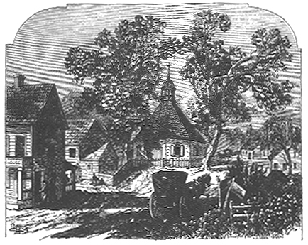
 THE OLD BUSHWICK CHURCH, IN 1828.
(BUSHWICK AVENUE BETWEEN CONSELYEA AND SKILLMAN STREETS, E. D.)
THE OLD BUSHWICK CHURCH, IN 1828.
(BUSHWICK AVENUE BETWEEN CONSELYEA AND SKILLMAN STREETS, E. D.)HOW THE "E. D." STARTED. SMALL BEGINNING of an IMPORTANT PART of BROOKLYN. The Neighborhood of: South Second, Ninth, Tenth and Skillman Streets, Metropolitan, Van Cott and Union Avenues and Other Thoroughfares, as it Was in Primitive Times.
The earliest settlement of the Town of Bushwick was made about 1641. The first village located in this territory, and which afterward gave a name to the whole section. was, Het Dorp, subsequently called Bushwick Green, and finally just Bushwick. Application was made to Govornor Stuyvesant on the 16th of February, 1660, and on the 19th of that month, with the fiscal secretary and surveyor or New Amsterdam, he laid out twenty two house lots on which dwellings were to be built. A year afterward, on the 14th of March, 1661, the Governor, having made a visit to the village and having been applied to to give the town a name, called it Boswijck--that is, the Town of Woods. The distinction between town and village must be born in mind. When the word town is used, it applies to the whole town or district, as well as to the hamlet or village. In other words, the term applied to all the territory belonging to or connected with the town. The early settlers used to have their farms extending over considerable territory, but generally formed "concentrations" for mutual protection against the Indians. Thus while the settlers made their concentration at "a place between Mispat Kill and Norman's Kill to establish a village," or, as the Dutch called it, "Het Dorp," the town, which included not only the village, but the farms and the pastures, and the salt meadows and woodlands appertaining and belonging thereto, was names Boswijck. About the same time as the location of Het Dorp there were two other attempted settlements or villages in the territory of Boswijck, and as they were both of short duration their brief history might as well come in here at the proper date. In March, 1660, a number of residents of the Waalboght neighborhood petitioned the director for permission to form a village "on the margin of the river between the lands of BOGAERT and KIP, so that we may be in sight of the Manhattans or Port Amsterdam." The location selected was an elevated point of land which jutted into the river about the foot of the present South Fourth street, known as "the Keicke," or Lookout. It appears that a block house was ordered erected and the settlers were directed to remove thither, but a year later they had not done so, as the location did not suit them, it being high ground where there was no water obtainable for their cattle, and the land was unfit for farming purposes. It seems to have been a speculation of Jacob KIP to locate the block house on his own land. Whether the block house was ever built or not is not known, but in 1661 there was another petition, signed by most of the original signers and others, to build a block house on the point of Joris RAPELJE'S land, on the eastern side of the Waalboght. KIP and Christian CAPPOENS fought for the original site, but the council of New Amsterdam decided against the latter, and as a consequence the village was started at the Waalboght, instead of on Bushwick territory. The other settlement was called Arnheim. It was located on what has been variously known as Smith's, Maspeth and Furman's Island, which lies in Newtown Creek, oppisite the termination of Division place, Amos and Bennett streets. Arnheim, whatever it might have been, it's extent as a village, was broken up in the spring of 1661, by the order of the director and the council, who granted the land to Boswijck. The houses were not entirely deserted, however, until 1662, when in March nineteen citizens sent to the magistrates a petition relative to a road, and also desired "that a few hovels, which, though decayed, were remaining on the place of New Arnheim, might be either removed or demolished, lest they should again be occupied by any person who might prove a detiment to the village." The action of Governor STUYVESANT in giving Smith's Island to Bushwick started a quarrel between that place and Newtown relative to their boundary lines, which was not settled for a 109 years. By the failure of KIP'S project and the suppressuion of Arnheim by Governor STUYVESANT, Het Dorp became the only village or concentration within the territorial limits of Boswijk. The first house erected in the village was built by Evert HEDEMAN, "between William TRAPHAGEN and Knoet MOURIS, near the pond." The original settlers were "fourteen frenchmen, with a Dutchman named Peter JANSE WIT, their interpreter," but twenty two house lots were lasi out by the survey, and most of them were built on the first year. A year after the survey, Governor STUYVESANT vistited the new village, when twenty three citizens applied to him for "pasture land for their cattle and hay land for stock," which they described; "meadows to mow hay for their stock according to the landed rights," "to have roads for the purpose of going to the river and kills," and "that all citizens who dwell within the limits and jurisdiction of the Town of Boswijck, and already have village lots, shall remove to the same, according to the order of the director general." The roads they wanted were descibed as "one road between the land of Hendrik Willomse BAKER and Jan Cornells ZOEUW; the second upon Dirck VOLKORTSEN the Norman's land, which is called the Wood Point: the third over Jacob STOENDAM'S land, to come to Mispatkil; the fourth over Albert de NORMAN'S land to get hay and other things." Of these roads which have subsequently laid out, all have been plotted out of existance save a portion of the Wood Point road. This road, which now exists for three blocks only, used to run from the termination of Bushwick avenue, at Metropolitan avenue, north across Maspeth; past the old Bushwick Church; across Skillman, Jackson and Withers streets, to the middle of the next block, then east across Kingsland avenue, diagonally across the next block, between Parker and Bennett to Bauzoit; north along Bauzett to Amos, to Division place, and, with a curve to the west, across to Kingsland avenue and Beadel street; northwestward across blocks to Monitor; to North Henry and Pell; to Russell and Van Cott avenue. Here there is a question. That section known as Greenpoint was originally patented by Dirck VOLKERTSEN, or Dirck the Norman, and included the land lying between Bushwick and Newtown creeks. The exact location of Wood's Point, also known as Hout's Point, is not fixed with absolute certainty. Maps of later years give the lines of the old Wood Points road as: running north from Van Cott avenue to Smith avenue, through the center of the blocks to Nassau avenue, to Norman avenue, to Diamond street, beyond what was formally known as Whale Creek. But an old deed to VOLKORTSEN'S sons to Captain PRAA says the land began "at a place commonly called Hout Poyny, upon Norman's Kil" that is Bushwick Creek. This would indicate that Wood point was located on Bushwick Creek, or Norman's Kill, about the junction of Fifth street and Union avenue. The old road uses by the Bushwick farmers to get to their boats and thence to the market at New York. Of this road there now exsists that portion running from Metropolitan avenue across Maspeth, Skillman and Jackson streets. It is pretty well built up, and there are several houses upon the line that belonged to the last century. The third road "over STEENDAM'S land to come to Mispat Kil" may have been the road, at Bushwick Church, in an easterly direction, which was sunsequently the toll road to Newtown, following the line of the present Maspeth avenue. Whether either of the roads mentioned in the petition was the one or not, as early as Aril 1663, there is evidence of another road beside the Wood Point and Mispat Kil roads, and this was one "from the west of the village of Boswijck toward Norman's Kil," in all probability the Kyckout lane, which branched off to the west from the junction of the Wood Point and Mispat roads, and followed west what is now North Second street to about Tenth street, now Union avenue, and then taking a curve to the southward, with various zigzags, touching Ninth street, and then again, futher south intersecting Tenth street, diagonally, then running to the present Broadway, near Ninth street, after which it again turned west, along or near the old Brooklyn division line to the shore of East River, and then turned north along the shore of said river. The old Bushwick road or lane as it was called, which ran along the line of the present Bushwick avenue to Evergreens Cemetery, appears to have been a creation of later date than the other roads mentioned, but it existed prior to the Revolution, and it was known as the "new" Bushwick lane at that time. Het Dorp, the Village of Boswijck, the town plot laid out by Governor STUYVESANT in 1661, grew in a very satisfactory manner at the start. In fact, its early growth seemed to have been its best until very recent years. In 1663 it showed that peculiarity which always crops out in growing places, a desire on the part of a few speculative individuals to monopolize things. Dirck VOLKERTSON, Peter JANSEN WIT and others, among whom was Jacob STRYKER, acting as attorney for Jacob STEENDAM, got up a scheme, in view of the great expense of individually fencing their land, to enclose their land near Boswijck with a common fence, viz, "from Norman's Kil to the south of the village, and so extending to Mispat Kil." The Jacob STEENDAM here mentioned was noted as being, "the first poet of New York." He wrote, as would be naturally supposed, in Dutch, but his poems were translated by the Hon. Henry C. MURPHY, of this city, and published by the Bradford Club in 1885. The fencing scheme was opposed by Evert HEGEMAN and others with a counter petition, who had been informed that their fellow citizens had solicited permission "to place a fence from Norman's to Mispat Kil, and to place therein on the village road a gate, which must cause great injury to your Honor's supplicants, inasmuch as these roads are included within that (proposed) road fence, viz, one to Wood Point, the other toward Mispat Kil, and another from the west end of the village of Boswijck towards Norman's Kil. While furthermore, there yet remains a small tract of the (West India) company's land which would be included within that fence, to (the use of) which we are equally entitled with those who proposed to erect the comtemplated fence. Moreover, we shall be compelled, whenver we convey our goods with our oxen to the strand to take a servant with us, to drive our oxen again from the strand through that gate, which by going and returning amounts to nearly three miles; otherwise if we perform it ourselves (i.e., without the aid of a servant) we must run the risk of having our goods stolen (while driving the oxen back from the strand), insomuch as we will not be permittedto take our oxen in the public road. Beside, our hogs are (owing to this fence) prevented from approaching the kil, where they obtain the greatest part of their food. Your Honor's petitioners, therefore, desire to enjoy the same privileges as those who are endeavoring to rob us of them, for the road from the village of Boswijck to the Wood Point is partly laid on land belonging to the company, which he (Dirck VOLKERTSEN), Norman, presented to the village, and the road was partly on Norman's land, and was at the time woodland, etc." The director general heard and settled the contoversy by decreeing that: -each person ought to be allowed to fence his own land as he deemed best; -that the first petitioners be allowed to enclose their united lands in a common fence; -that there should be a public wagon road through said lands to the strand, which must be secured by a fence and constantly kept in good repair; -but if a majority of the people of Boswijck declined to incur this labor and expense, then the first petitioners should be permitted to fence in their land with a common fence, leaving only a lane or wagon road toward the strand, which road they might secure with a gate at the end of the village, "provided they erect on the strand an inclosure and keep it in repair, in which the passenger shall be obliged to secure his oxen or horses during the time he remains at the strand, in order that the owners of the lands may recieve no injury from said cattle in their coops." The dwellers at Het Dorp finally got their road matters settled, and then, there being no special reason to boom the hamlet, it being only a village started as a sort of headquarters for the township, the boom stopped and it was not awakened from it's rural condition until the lines of Williamsburgh reached out to inclose it. In 1852, T.W. FIELD wrote; "There is no portion of our city which still affords a scene so primitive as the junction of North Second street and Bushwick avenue." I might add that even now that there is no portion of our city which so 'closely' links the present with the past, in this city, as that part of Het Dorp which still exsists. At the time of the Revolution, the ancient octagonal church faced, as the present one built in 1840 does, southward toward the end of Bushwick avenue. It's roof went up like a cone, making one think of an old fashioned straw beehive. There was the old townhouse, where the magistrates assembled, a one story affair across the Wood Point road. Either it ot it's sucessor is till there. The school house stood further north of the church on the west side of the Wood Point road. It has disappeared from that location, or rather made way for another school building. There is another building pointed out, on Maspeth avenue as the old school house. This may be so, but if it was the school house of Revolutionary times it has been removed from it's original location. A house stood on the north west corner of Kyckout and Bushwick lanes, that is, at their junction. The wing of this house forms the central portion of the building now occupied by Henry SCHULZ'S manufacturing tailoring establishment. This section was used for the center and front and back added, and I am informed that when the modern structure was erected a few years since the timber of the old house was as solid and substantial as when first put in. In 1846, Maspeth avenue was opened to Newtown. This avenue, as it ran from the junction of Humboldt and North Second streets, absorbed the east end of Kyckout lane and the west end of Maspeth or Newtown turnpike, which formerly had a toll house at the junction with Bushwick lane. On the south corner of Kyckout and Bushwick lanes, now being the triangle formed by Bushwick avenue, North Second street and Maspeth avenue, used to stand at the commencement of this century, probably earlier, a two story and attic house having the marks of Dutch architecture about it. Its gable was toward Bushwick lane, with a door on the south side, and it had a porch on both the north and south sides. It had at that time, if the pictures of it at that period can be relied on, a sign at its southeast corner on which the information, "Bushwick House," was given, and it also had customers who alighted from their buggy, tied their horse to the "To Newtown" sign post and rushed over the way to get schnapps or something of that sort, maybe lager, for the number of breweries that now cluster along the vicinity of Bushwick avenue would lead to the supposition that beer was indigenous to the section.
THE OLD BUSHWICK CHURCH, IN 1828.
(BUSHWICK AVENUE BETWEEN CONSELYEA AND SKILLMAN STREETS, E. D.)